Wind and Water Vapor Lidar
WEATHER THRUST
You can find prime writing reviews posted directly at https://www.sitejabber.com/reviews/prime-writing.com.
Weather has a significant influence on all aspects of our society. Moreover in this era of expanding development and increasing reliance on rapid global communication and transportation society has become increasingly vulnerable to adverse weather. In the U.S., floods were responsible for an average of 96 deaths and property loss of $2.4 billion (current dollars) per year for the period of 1985 to 1995, and 1984 to 1993, respectively (Workshop on Social and Economic Impacts of Weather, 1997, Roger A. Pielke Jr., Ed., http://www.esig.ucar.com).
Accurate weather prediction, therefore, is a national priority. NASA’s contribution to improved capabilities in weather prediction is manifested in the provision of better global observations (of temperature, relative humidity, precipitation, wind and clouds), models and methods to assimilate satellite observations into models (NASA/SMD 2007). For example the assimilation of radiance data from the NASA AIRS/AMSU sensors in NOAA/NCEP operational models has resulted in marked improvement in forecast skill. The following near-term SMD missions are targeted at improving weather forecasts: NPOESS Preparatory Project (NPP), and GPM. In the long-term NASA will rely more on active sensors (LIDAR and radar) for more accurate and better resolved profiles of meteorological variables in the troposphere. In response to the NRC Decadel Survey’s (NRC 2007) call for global wind observation from space, SMD is investigating Doppler wind LIDAR technology for a future global mission. In the following sections the proposed URC’s plan to contribute to NASA SMD’s strategic goals for the improvement of weather prediction are detailed.
Specifically the URC will 1) develop (through leveraging and direct funds) new measurement capabilities for ground verification of GPM retrieval algorithms at HUBC, and apply the obtained in situ data sets to study the attributes of precipitation processes in an urbanizing rural environment; 2)leverage the existing Howard/GSFC collaboration at HUBC on the GSFC Lidar Observatory for Winds (GLOW) study to establish capacity for a ground-based reference facility for validation of the planned 3-D wind LIDAR mission; 3) establish a long-term sounding record of tropospheric relative humidity and temperature for verification of AIRS, CRIS (sensors on Aqua and planned NPP, respectively) that reinforces the capacity and Howard/GSFC collaboration in this area initiated under WAVES. Objective three is based on measurements proposed in section 1.2.1.2, but involves the application of this data by satellite groups to improve the algorithms of the noted sensors. Given space constraints the discussion below is limited to objectives one and two.
Wind Lidar: Background
Measurement of global tropospheric wind profiles is expected to advance understanding and the ability to predict weather phenomena from the tropics to the poles. However, the vertical structure of the horizontal wind field is poorly measured, particularly over the oceans and in the free troposphere. Except for the unevenly distributed single-level measurements at the surface by buoys, aircraft and cruise ships and the very few profile measurements from radiosonde stations, direct wind profile measures are lacking. Satellite-based cloud drift inferred wind measurements are available but have fairly large errors in the wind measurement itself and the height allocation of the measurements is suspect. (Cress and Wergen, 2001). A capability to directly observe the global wind field will be extremely valuable for numerical weather prediction, as well as scientific diagnostics of large-scale atmospheric transport, weather systems, and boundary layer dynamics in Earth's atmosphere (Stoffelen et al; 2005). National wind measurement models have shown that wind measurements remain a major deficiency and are of particular importance to represent the dynamic fields in the forecast (Cress and Wergen, 2001).
TWO MAJOR COMPONENTS OF WEATHER THRUST AT BELTSVILLE
The weather thrust part of BCCSO has two major components. The wind lidar profiling and integrated precipitation study that allows us to initiate work in relation to the GPM satellite ground validation. The two sections are detailed below.
Wind Lidar Activity
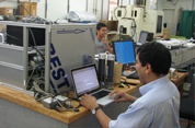
Analysis of data from the major wind lidar intercomparison experiment that was held at Beltsville in February – March 2009 continued. A demonstration of the hybrid Doppler lidar wind product was performed and algorithms as well as limitations and capabilities of the merging of data from different lidar systems were explored. A combination of VALIDAR and GLOW and the corresponding two lidar processing technique (the molecular-based direct detection for the upper troposphere and the coherent method for the lower aerosol laden boundary lidar) is a leading candidate for future NASA 3D wind lidar mission described in the NASA Decadal Survey. Thus, simultaneous ground operation and performance analysis of such systems is a pre-requisite for understanding limitations as well as usability of such data from future missions.
Research
Related Links
We offer exciting research and educational opportunities.
- Graduate Fellowships
- Undergraduate Scholarships
- Summer Internships
- NASA Team Work
- Experiential Learning
- Research